Sunday, April 28, 2019

Wandering to Wittenberg for a sunrise in April.

  It has been said April is the cruelest month, not separating from winter and teasing us with summer days. It may drive some crazy, but I find being in the extreme elements makes me appreciate the good weather that much more.

   This adventure started with rain showers most of our drive to the Catskill mountains in eastern NY, where Evan decided to have our April sunrise hike, and this one would be an overnight as close to the summit to shorten our early hike in the morning.
  When we arrived at the Woodland Valley campground the temperature was a cool 45 degrees with sprinkles and a complete overcast sky. The Wittenberg Cornell Slide trail was marked with red markings between two campsites, then a bridge over Woodland Creek and going almost straight up to begin, and the winds began to howl...
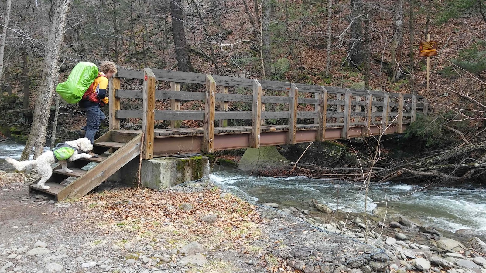
Evan and Lucy crossing the bridge


  The steepness didn't last for long as we approached the top of the first escarpment where the landscape plateaued for a pleasant change from the steep start. This area of the forest was captivating, as large growth pines and hardwoods were scattered with waterfalls and small creeks flowing through the landscape. The winds remained howling overhead through the tree tops as the drizzle of rain suddenly turned to snow and pelting hail.
Notice the drop to the right. We are at the top of the first escarpment.

  The trail changed from steady ascents to flattening grades, which were heavily pooled with flowing water, creating streams running the contours of the path until we reached the intersection of  Tonisgah trail, approximately two and a half miles from where we started. At this junction the trail followed an old cart road, which made for easier hiking until we approached the steep chutes leading up to the summit.


  With the steep northeastern slopes still packed with ice and snow in areas, it warranted slow, methodical climbing up the three major chutes until we reached the fairly flat summit. The higher we climbed the more the wind was forcing itself through the trees, as it pelted us with frozen pellets of moisture and snow.
The summit was in a cloud when we arrived

  We quickly found shelter from the winds, pitched our tent and hunkered down inside for the night.
  The winds were whipping the tent walls, pushing them, shrinking the space inside as we stayed warm inside our mummy bags.

Our resting spot until morning

  In the early morning hours, as I opened my eyes from a less than restful slumber, the tent was illuminating from the skies above while the winds continued to shake the tent.
Waking up to a dusting of snow

  At first glimpse, outside the tent, we noticed a small dusting of snow blanketed the ground and the sky was glowing towards the eastern horizon, with stars still visible in the dark western direction.

First glimpse of the celestial heater

  This was the first sunrise, in our quest, that the temperature was bearable and made it enjoyable to observe the sky's colorful show, as the sun peeped over the mountains in the eastern horizon, its rays reflected off the few wispy clouds floating in the sky, creating a unique display for this morning's sunrise. Each morning's sunrise is like a fingerprint, unique, never to be witnessed again.

Evan watching the sun's display

   It wasn't until we started these sunrise hikes that I noticed the steady quickness from the sun's first appearance on the horizon until it seems fully suspended above, so before we knew it, and after many pictures, the celestial heater was warming us as it's rays were illuminating the summits across the land before us, in a soft orange hue, from east to west.

Looking to the southwest with the sun's rays kissing the eastern side of the mountains


Is it a morning angel?

  We returned to our tent and proceeded to break down camp, packing everything into our backpacks for the icy descent, which now had a thin covering of snow.

One of the cool rock formations on the upper elevations.

Lucy had troubles on some of the steep chutes

  After descending the upper elevations through the ice and snow covered rocky chutes, the remainder of the hike was pleasant under clear skies and cooling winds.
  Evan definitely chose a great overnight hike for our April sunrise and the weather cooperated for this time of year. It was nice to have different scenery than we are used to in the White and Green mountains. I'm looking forward to what he plans for May!

Evan's blog: Evanhikes
Our GPS track:  Day 1
                          Day 2

Monday, March 11, 2019

Spectacular Colors from Camel's Hump

  Camel's Hump mountain in Vermont was Evan's choice for our March sunrise and Saturday morning's weather seemed the best choice this past weekend, so our decision to go lead us to a night of no sleep. After working until 11:00 pm Friday, Our only choice was to travel to Vermont directly after.


  We arrived at the parking lot shortly before 4 am which, according to my calculations, we could catch at least 40-45 minutes of shut eye before beginning the two and a half mile trek up Burrows trail on the west side of Camel's Hump. It's a heavily trafficked route in the winter so I wasn't surprised to see the trail broken in by others over the last few days, which means an easier and quicker climb!


 After a robust slumber of approximately 40 minutes in the parking lot, we prepared for our hike. I chose to use snowshoes, while Evan's choice of traction was spikes. The trail was firmly packed as it wound through the hardwoods of the lower slopes, so either form of traction worked well, but Evan's spikes were definitely the less bulky choice.
  Following the tunnel of light directly in front of me, like a sleepless zombie, I wasn't able to see much of our surroundings. The temperature was of average winter temps, the clear skies above us displayed glitters from distant stars spread across the black canvas of the night sky. It was a peaceful start for a hike.


The only view hiking in the dark.

   Evan was definitely feeling the effects of no sleep because he was very quiet, which isn't like him during hikes. He's usually squeaking out so much trivia and info on New England geography that I am on the border of madness realizing how little I know about areas that I've spent much of my time tramping around for 40 years. Other than a frequent grunt or groan and the dim light ahead of me from his headlamp, I wouldn't of known he was accompanying me on this hike.
  Time and trail seemed to be fading, and the night sky brightening, as we slowly struggled up the steep grade of the trail. Looking towards the skies I noticed the stars were slowly disappearing from the illuminating glow creeping from the east. After our last few sunrise hikes leading us to hunker down in bone chilling temps and winds while waiting for the sun to appear on the horizon, it appears this may be the first sunrise in our quest that our summiting may coincide with the sunrise.
  At two and two tenths of a mile we had reached a clearing where Burrows Trail intersects with the Long Trail. At this point the sky was so bright that I took off my headlamp and picked up the pace to complete the last few tenths of a mile, where the trail became more steep, to be sure we arrived before our star enters the horizon. Our timing was impeccable as we were taking photos shortly after arriving on the summit.
The bright sky from the steep slopes just before the summit

  The winds were steady with a few bone chilling gusts from the west, so we found a spot behind some ledge on the east side of the summit and watched as the best sunrise we've experienced so far was displayed before us. That fireball in the distance slowly climbed as it illuminated snow capped peaks and ridge lines sprawling out between us and the horizon in a pinkish orange hue.


  Once again I had tried to use my GoPro Hero 7, but the temps were to low and the battery did not respond when needed, so all pictures were taken with my phone... I must remember to carry the GoPro in a pocket that stays warm.


Looking south towards an illuminating sky before sunrise

  Evan was appearing to be rejuvenated as he was chatting up his usual naming off all surrounding peaks, hills, ridges and whatever other geographic landmarks in our 360 degree view. I think his mind has been programmed by Google Earth...
  Now that we were surrounded by daylight and our bodies were feeling the outlandish temps, we decided to make our way down. The beauty of hiking up in the dark and down in daylight, for me, is that it feels like a different trail. Now, on the descent, all that we missed beyond our headlamp lit tunnel of light was on full display around us.

The colors of this sunrise were spectacular.
   The trail descended from the summit on the west side, where we dropped out of the direct sunlight and into the shadow of the mountain where the winds were whipping until we quickly entered treeline, which protected us.
Me trying to keep up with Bella.


Mt Mansfield in the distance.

Evan on the summit

Silhouette pose. I'm really liking these photos

Bella in a rush to descend.
  The descent was picturesque of a typical winter day in Vermont, with Spring creeping it's soothing sounds and sights around every bend in the trail. The birds were singing as we welcomed the warm rays of  sun through the trees, beaming it's warmth on our backs as we were beyond the shadow of the mountain. Evan seemed to be rejuvenated, like the energizer bunny with a new set of batteries, as he was testing my lack of knowledge in mixed trivia of mountains and geography of the Adirondacks that were in the distance to the west.
   It was nice to see him back to himself after a grueling sleepless night, hike and sunrise. Check out his blog here: http://evanhike.blogspot.
 
Our GPS track: https://www.strava.

Thursday, February 21, 2019

Morning on Monadnock

  With our failed attempt of a sunrise from Mt.Monadnock last week, due to cloudy skies, we were off for a chance of better skies this weekend. We questioned if we should return to the same mountain for sunrise or if we should venture somewhere else. After looking into other hikes, we chose to return, as we felt the mountain was worthy of being one of our destinations for our quest.


This was our quick glimpse of the sunrise the week prior before the clouds took over the skies.

  With Mt.Monadnock being the second most traveled mountain in the world, even in the dead of winter at just before five in the morning, the parking lot had a few cars in it with other hikers seeking out an early morning hike.

 Our hike started out following a tunnel of light cast from our headlamps focused on the ground ahead, which was clear of  snow and ice that covered the trail only a week ago. The skies looked perfectly clear of any condensed water vapor floating above us to obstruct any views. The stars were clearly visible and the early morning air was bitterly cold with a slight wind.

  Evan had planned for us to tramp along the most traveled route up, which is a short more direct route of just under 2 miles to the summit. White Dot trail starts as a wide, root and rock garden that progresses up a steady incline until open faced granite slabs expose you to the elements at higher elevations where, in these conditions, the challenge starts.

   Although most of the snow and ice melted since our visit a week ago, the few patches that were left happened to be on these steep exposed slabs of granite. The winds started picking up at these elevations, so once we made it just below the summit where the giant cairn lies we hunkered down out of the winds to await the sunrise.

The brightening skyline.
The first glimpse of the sun on February 10th, 2019.
Evan capturing the show. Read Evan's Blog here: Evan Hikes
First rays of sunshine illuminating the rocky ledges.
   We watched from these lower ledges for a few minutes as the sun slowly crept above the horizon, then we trekked the last few hundred feet, passing the hikers that were heading down, until we arrived on the empty summit.

Evan enjoying the sunrise from the summit.
   After a few more photos from the summit, we found our way to the Dublin Trail in order to connect it to White Arrow Trail. Before heading down, we enjoyed a vast view of southern New Hampshire and Vermont, with peaks like Mt.Kearsarge, Stratton Mountain, and Mt.Ascutney visible. With the winds reminding us of the chilling time of year, it was time to descend.

White arrows mark the route down (lower right).
The White Arrow Trail made for a fun rock scramble!
Can you follow the arrows up? 
Follow the arrow...
As soon as we left the exposed rocky higher elevations the trail became more icy until the ice engulfed the trail like a mad river that instantly froze as it gushed down the steep slopes. It made for a treacherous descent, but a fun one.

 
The ice appeared to be a few feet thick, covering every inch of the trail and surrounding area, at this point spikes were necessary and without them we would of had no choice but to head back to where we came from... Luckily we came prepared and with the proper equipment this trail and it's conditions were spectacular!

Looking down the frozen trail.
Looking up one section of the frozen trail.
   The frozen river that was marked as a trail seemed to go on forever. When the slopes leveled off we found the bog bridges were engulfed in the frozen waters they were supposed to bridge across. What irony!

Bog bridges frozen solid.
   The White Arrow trail lead us to a junction after approximately a mile where the Halfway House once stood. From here we located Hello Rock trail which we followed for approximately half a mile winding through rock outcroppings, pines and hardwood forests until we connected to Cliff Walk and Parker trails with a combined trek of 1.2 miles to end, where we had begun at the Monadnock Park Headquarters.

Frozen waters flowing over Poole Reservoir Dam.


Looking across Poole Reservoir
 The GPS route we took: https://www.strava.com/activities/2137096115